Using corals to protect coastal infrastructure

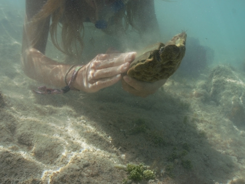
Collecting rescue corals from oil dock pylons to be replaced. Credit - S. Sarkis.
Using corals as a nature-based breakwater to protect coastal infrastructure from storm waves
Bermuda is one of the 14 UK Overseas Territories; a 50km2 island situated in the Atlantic Ocean (32°N, 64°W), geographically isolated from the Caribbean Sea and 1,000 nautical miles (1852km) from the East Coast of the US. It is home to the most northern tropical coral reef ecosystem and is classified as ‘High Risk’ due to its proximity to a densely populated land mass (1,145 people per square kilometre) (WRI, 2004). Like other coral reefs, climate change factors such as temperature and ocean acidification are threats to be considered, but Bermuda’s high latitude reefs associated with lower sea surface temperatures are less vulnerable to known climate-related consequences such as bleaching, than their southern counterparts. Ongoing threats to the health of this ecosystem relate to the increasing needs and developments associated with a strong international business and tourism sector, which results in the destruction of reefs from coastal development and vessel groundings.

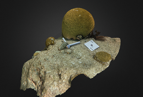
Using epoxy to plant coral. Credit - Yannick Hillier.
Against this background, an immediate concern is the lack of ‘formal’ process for reporting and restoring coral damage. This impacts the goods and services provided by the reefs to the island, estimated at $1.1 billion per year. More specifically, the efficacy of coral reefs as a breakwater against storm waves, the availability of habitat provided to commercially fished and other marine species, and the tourism product they generate all become affected by business and tourism-driven activities (Sarkis et al., 2013).
Living Reefs Foundation (LRF) was the first and only organisation in Bermuda to launch a coral restoration research programme through its Coral Garden Initiative (2016). LRF’s Coral Gardens serve as a tourism attraction and as an ocean-based nursery used by scientists and students as a study site. Since 2016, LRF has engaged tourist operators, visitors, residents, and universities in research and hands-on restoration through laboratory and field projects, and participatory workshops and tours. LRF routinely mentors university undergraduates from the UK, the US, Canada, and Spain, whose work contributes to protocols for various aspects of coral culture. The Foundation’s main scientific focus is on accelerating coral growth rate by adapting restoration methodologies to Bermuda’s reef-building coral species, and investigating innovative application of emerging technologies on the early life stages of corals.
Fast forward six years since its beginnings, LRF has produced a source of young corals from seven boulder-form species, started from microscopic larvae in the Foundation’s land-based hatchery and grown on its coral gardens. LRF also rescues corals, identified by government officers to be in danger of physical destruction from the construction of docks or other coastal activities. Rescue corals are assisted in their recovery in the hatchery facility, and translocated to selected sites where they boost coral cover.
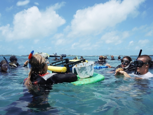
Restoration course for university students. Credit - Yannick Hillier.
The 2022-2023 project funded by Darwin Plus Local uses homegrown and rescue corals as a nature-based strategy to enhance coral reefs with a high coastal protection value. This ‘Causeway project’ targets a 1km long bridge linking the airport to most of Bermuda, bordered by patch reefs and a partial man-made boulder barrier. The goal of this pilot study is twofold. Firstly, the study aims to demonstrate the potential use of coral planting to strengthen man-made barriers by turning it into a live and growing reef. Secondly, it aims to quantify the impact of restoration with a high-resolution 3D mapping photogrammetry tool, enabling a 3D model representation of the changing reefs and an assessment of coral growth over time. The buy-in of government is key to long term success in integrating coral planting as a strategy to fortifying natural coral and man-made barriers to protect key infrastructure from storms. The predicted increase in frequency and strength of hurricanes in the Atlantic calls for precautionary measures in mitigating damage to coastal infrastructure affecting the livelihood and well-being of island communities. Coral planting in key areas will contribute to the growth of a breakwater and increase its cost-effectiveness in the long term.
The project has built capacity in Bermuda by providing LRF with the computer infrastructure and training to map large areas of the seabed in high resolution and 3D with the assistance of Tritonia Scientific Ltd, our UK-based consultant. This led to the engagement of two Bermuda government departments – the Department of Environmental and Natural Resources (DENR), and Works and Engineering (W&E) – as well as engaging the Diving sector of Bermuda, operators, and volunteers. This not only raises community awareness on the importance of corals to the island, but also increases capacity in restoration by training residents and government officers in various aspects of field and monitoring work. The project provides data on the resources needed for using corals as a nature-based solution – resources such as coral production capacity, coral planting operational needs, and associated costs. It also provides a quantification method through photogrammetry technology for site assessment with respect to coral cover and substrate capacity, and for restoration impact by measuring coral growth over time.
The protocols developed during the study are applicable to the implementation of marine spatial plan objectives related to marine habitat restoration, such as seagrass and corals; both of which are included in the newly drafted Bermuda Marine Spatial Plan. Data obtained from this study will inform senior officials on alternative strategies to build long term resilient breakwaters and increase their cost-effectiveness by reducing maintenance costs normally incurred by man-made barriers. It also provides a powerful mapping tool which can be used to quantify, for example, impacts to the seabed by vessel groundings, and baseline mapping for Environmental Impact Assessments. One of the main outputs of the project is a technical manual on the quantification of restoration efforts using photogrammetry, made available through the Foundation’s website.
For more information on this Darwin Plus Local project DPL00004, led by the Living Reefs Foundation, please click here.